

Get ready for a road trip to explore beautiful Charlotte County! This guide
will lead you to stops along the way to discover the history and people of
the county. Learn about historic homes and buildings; the ocean floor and
tides, famous people; the natural world and more. As you travel, use your
imagination to create art, build constructions, write about your trip, draw or
paint pictures, and play games. Bon voyage!


PLAN YOUR TRIP
Before a trip, it’s a good idea to plan ahead. This guide is designed for you to start your journey in the southwest corner of the county, at Passamaquoddy Bay, the traditional territory of the Peskotomuhkati Nation. The Peskotomuhkati people lived here for centuries; Qonasqamkuk, the present site of St. Andrews, was their fire place where the councils of the Peskotomuhkati nation were held. Learn more about the Peskotomuhkati Nation here: https://qonaskamkuk.com/ Your journey starts in St. Andrews, then travels to St. Stephen, McAdam, St. George, Pennfield, Blacks Harbour, Deer Island, Grand Manan Island, Campobello Island, and many places along the way. You may wish to start somewhere else in Charlotte County or drop into an interesting community.
No matter, use your imagination and explore places in the guide!
PACKING for the JOURNEY
Before you start your trip, think about what you may need along the way. You will need a map to plan your itinerary, and perhaps a journal or diary to record your adventures. How will you get around the county? You could travel by foot or by bike, but the fastest way is by car. How about building your own vehicle?
Activity: Build a pasta car https://science.discoveryplace.org/stay-at-home-
science/build-your-own-pasta-car
ST. ANDREWS
Check out these fun places – town wharf, walking/biking trails, parks and green spaces, Katy’s Cove and the shoreline; playground at Vincent Massey Elementary school; alpacas and peacocks at Kingsbrae Gardens and much more. You will be sure to see many historic homes and buildings, including museums and historic places – they have stories to tell about the people who lived and worked here.
Some highlights are listed in this guide. You can also download an online walking tour here:
https://www.standrewscivictrust.ca/resources/teaching
Charlotte County Courthouse
Builder Thomas Berry designed and built the Courthouse in 1839-40. Check out the interior to see the judge’s dais, and wood railings to separate the accused from court officials. Look at the photos of the royal children of King George III and Queen Charlotte of England who reigned from 1760 – 1820, when the streets of St Andrews were laid out in a grid and named. Can you find streets named after the 13 royal children? As well as trials, the Courthouse and the green area in front were often the site of community events such as fairs, and parades.
https://www.townofsaintandrews.ca/directory/charlotte-county-archives-courthouse-gaol/
Right next door is the Charlotte County Jail, built in granite with slit windows with iron bars. Visit the jail to see how prisoners lived and learn some of their stories. Three young boys were imprisoned here once for stealing bread. One night, the jail door was mysteriously left open and they managed to escape. Visit the cell where they were kept. This building is also the home of the Charlotte County Archives https://ccarchives.ca/
One Architect – Three Communities
Architects have designed many homes and buildings in Charlotte County. In the early 1900s, a total of 10 homes and buildings in Charlotte County were designed by Montreal Architects Edward Maxwell and his brother William C Maxwell. The three Charlotte County communities with Maxwell designed buildings are St.Andrews (11 houses); Minister’s Island (home, barn and outbuildings); and McAdam (railway station). Learn more about Edward and William Maxwell at these links:
https://cac.mcgill.ca/maxwells/essay/01.htm; and
https://www.standrewscivictrust.ca/resources/technology
Activity: Identify Architectural Elements
To experience what life was like in the past, visit buildings, museums and historic places in St. Andrews. See if you can match the following architectural elements with the correct historic building.
| Architectural Element | Historic Building | ||
|---|---|---|---|
| 1 | Triangular pediment and frieze with 4 columns | Ross Memorial Museum | A |
| 2 | Two massive brick chimneys | Charlotte County Courthouse | B |
| 3 | Slit openings in stone walls | Sheriff Andrews House | C |
| 4 | Gun slits in wooden walls | Charlotte County Jail | D |
| 5 | Thatched roof, and turret with sailing ship wind vane | St Andrews Blockhouse | E |
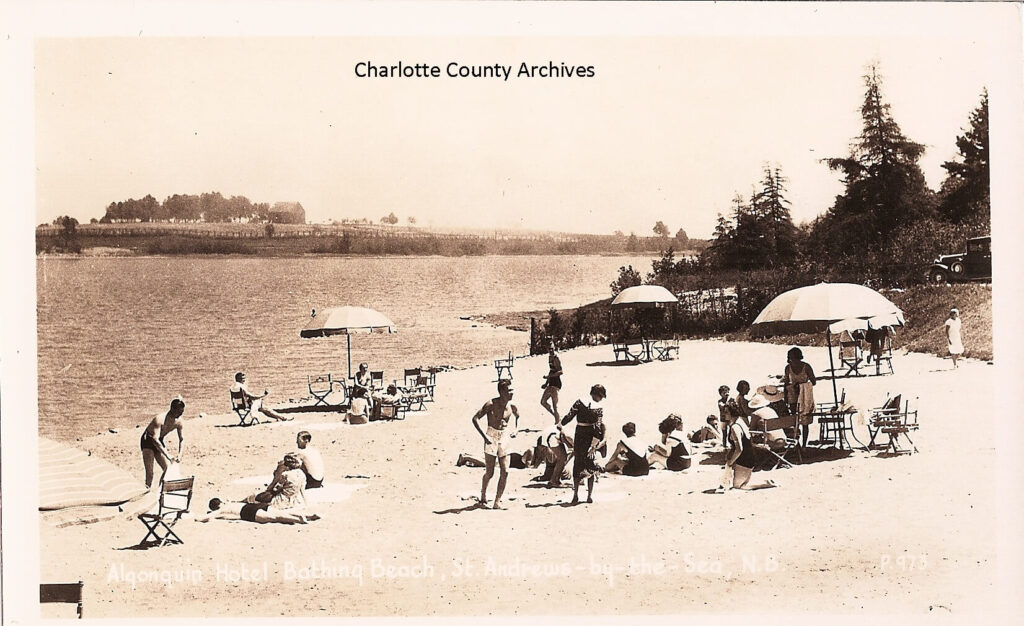
| 6 | Fan window and sidelights | Algonquin Hotel | F |
| 7 | Watch tower | Pansy Patch | G |
Answers:
A-6 / B-1 / C-2 / D-3 / E-4 / F-7 / G-5
For more information about historic places in St. Andrews, visit NB
Register of Historic Places at http://rhp-rlp.gnb.ca.
PASSAMAQUODDY BAY
St. Andrews is surrounded on three sides by Passamaquoddy Bay. The abundance of marine and sea life can be explored on beach walks along the shore at Indian Point Park, sacred ground of the Peskotomuhkati Nation; a visit to the touch pools at the Huntsman Marine Science Centre; seeing wild salmon face-to face at the Wild Salmon Nature Centre; and walking across the ocean floor at low tide to Minister’s Island.
See links here: https://www.huntsmanmarine.ca/; https://www.asf.ca/about-
atlantic-salmon/wsn
Activity: Field Drawings
With lots to explore, you can learn more about the ocean by searching for seashells, sea glass and special rocks, driftwood and pebbles. Look for evidence of shellfish, seabirds and other examples of marine life. You may see right whales, porpoises, seals or sharks. Record your observations on a chart like this one:
| Your Field Drawings | |
|---|---|
| Observations | |
| Name of finding (ie clam) | |
| Material (ie shell) | |
| Location | |
| Colours | |
| Shapes or Patterns | |
| Textures |
Make a Field Drawing of your Finding:
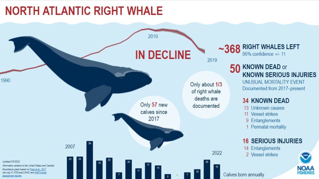
WHALES IN PASSAMAQUODDY BAY
Did you know North Atlantic Right Whales can live for 70 years, weigh up to 63 metric tons, and grow up to 15.8 meters? As you wander along the shoreline or from a boat, you may see Right Whales who feed on plankton with their heads slightly above the surface. They often feed in Passamaquoddy Bay, especially during the breeding season (July to September). This whale is an endangered species with only about 330 known to live in the world.
Learn more about Right Whales here:
https://oceana.org/marine-life/north-atlantic-right-whale/
https://lastoftherightwhales.com/the-film/
Activity: #Debrisfreefundy
You can help whales and other marine mammals by collecting marine debris, fishing rope and litter along the coastline. To date, more than 40,000 pounds of discarded rope from the marine environment has been collected through the use of rope recycling bins.
Look for bins to drop the fishing rope you collect on wharves in Dipper Harbour; Beaver Harbour; Black’s Harbour; Seeley’s Cove; Back Bay; Huntsman Fundy Discovery Aquarium and the town wharf in St. Andrews; Lord’s Cove on Deer Island; Head Harbour on Campobello Island; Seal Cove, North Head, and Ingall’s Head on Grand Manan; and the harbour at White Head Island.
Learn more about marine debris:
https://www.huntsmanmarine.ca/debrisfreefundy
https://oceantoday.noaa.gov/fullmoon-trashcounts/welcome.html
https://www.fundynorth.org/ghost-gear
MINISTER’S ISLAND
This small island near St. Andrews is a fun place to explore, and can be reached by walking or driving along the ocean floor at low tide. The first step in planning your visit is to check the tides, so you know when you can cross and when you must return. The highest tides in the world are in theBay of Fundy which includes Passamaquoddy Bay. Learn how the moon has an impact on tides. https://sciencing.com/relationship-between-moon-phases-tides-5038199.html
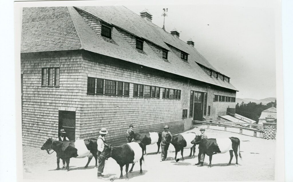
On the island, learn about Sir William Van Horne, former head of the Canadian Pacific Railway (CPR), who built a summer estate with an impressive livestock barn and other farm buildings, carriage trails, bathhouse, creamery and more. He enticed Montreal Architect Edward Maxwell to design his home and with Van Horne’s help, Maxwell went on to design other houses and buildings in Charlotte County. Visit here: https://www.ministersisland.net/
Maxwell also designed a fantastic building in the nearby village of McAdam. Travel there to check it out! https://www.rhp-rlp.gnb.ca/
CHAMCOOK MOUNTAIN
For a beautiful lookout over St. Andrews, Passamaquoddy Bay and St Croix River, hike the trail to the top of Chamcook Mountain. Start at the Rossmount Inn Hotel parking lot. Built with dry stone walls for carriages, Henry Phipps Ross and his wife Sarah Juliette picnicked with their friends here. As you climb the mountain, keep an eye out for insects, moss and native plants, while respecting the mountain and protecting its natural beauty.
https://www.hikingnb.ca/Trails/FundyWest/StAndrews/ChamcookMountain.html
The Rosses later purchased what is now the Ross Memorial Museum in St. Andrews. Visit the Museum to learn more about the Rosses, their collections and their love for St.Andrews. https://rossmemorialmuseum.ca/
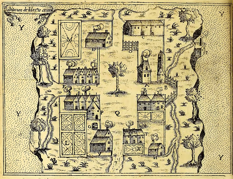
ST. CROIX ISLAND
On this tiny island, known as Muttoneguis, Muttoneguamus, Metanegwis or Metnegwis by the Peskotomuhkati, the beginnings of the first permanent French settlement in North America took place in 1604 under the leadership of Pierre Dugua, Sieur de Mons. Samuel de Champlain, the expedition’s geographer and one of the 79 men who attempted to build a settlement on the island, drew maps and plans of the habitation and kept a diary about their disastrous winter when 35 of the crew died of scurvy.
https://www.pc.gc.ca/en/lhn-nhs/nb/stcroix/culture/colonie-colony.
https://www.pc.gc.ca/en/lhn-nhs/nb/stcroix/visit
ST. STEPHEN
The Peskotomuhkati people were the first inhabitants along the St. Croix River spending part of the year here for centuries. What is now St. Stephen was settled first by French settlers, then by Loyalists from the American War of Independence (1775-83), and later by disbanded soldiers from the American Civil War (1861-65). St. Stephen became a seaport, a port of entry to the United States and a centre for lumbering and shipbuilding. Many of the grand houses, wharves and other buildings reflect the town’s early lumbering history.
Fun things to do include walking and biking along the Coastal Link Trail which starts on the waterfront near the old train station in St.Stephen; swimming in the indoor pool at Garcelon Civic Centre; and visiting the Charlotte County Museum.
https://www.facebook.com/CharlotteCountyMuseum/;
https://town.ststephen.nb.ca/garcelon-civic-center;
https://coastallinktrail.ca/the-trail/
In St. Stephen’s past, factories were built to produce cotton, soap, shoes, baskets, axes, cigars, and carriages. The famous Ganong Bros candies and chocolates first made in 1873 are still available at the shop in the Old Ganong Candy Factory on Milltown Boulevard. After discovering chocolate was more practical to carry covered in paper, Ganongs began making chocolate in wrappers – chocolate bars! https://ganong.com/
Visit the Chocolate Museum nearby. https://chocolatemuseum.ca/ Up the street from the Chocolate Museum is St. Stephen’s University, once a boarding house for young female workers who came from Newfoundland, England, Scotland, Wales and elsewhere to work in the Ganong factory. https://ganong.com/our-sweet-story/
Activity: Make your own chocolate treat using Ganong’s candies
https://ganong.com/recipe-chicken-bones-gluten-free-brownies/
As well as the chocolate Ganong’s, another famous Ganong is celebrated in St.Stephen. Along the town’s waterfront, look for the bronze sculpture of William Francis Ganong (1864-1941), a scholar and outdoorsman known for cartography (map making), and the study of botany and geology. He hiked and travelled by canoe over much of New Brunswick, mapping rivers, streams and lakes, studying wildlife, and photographing the landscape and geological features. One of his maps illustrates the territory of the Peskotomuhkati Nation. https://qonaskamkuk.com/wp-content/uploads/2017/04/Photo-09-600×600.jpg
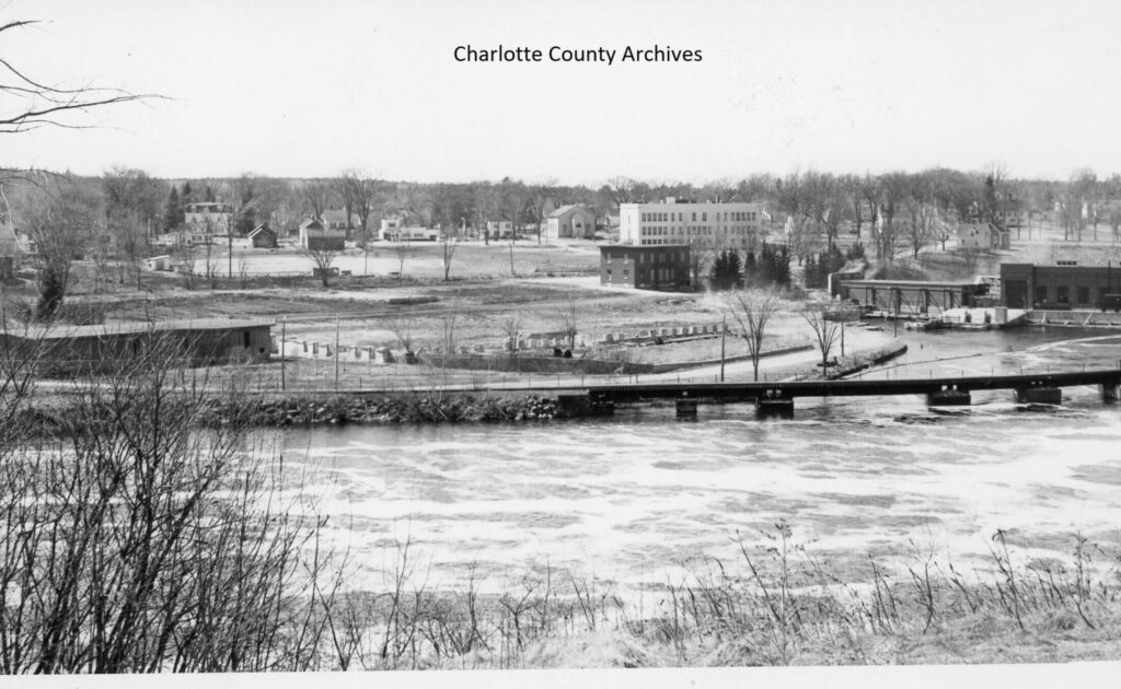
Other historic homes in the former community of Milltown, now part of St. Stephen, were once boarding homes for female workers who worked at the St. Croix Cotton Mill. At its peak, the mill employed 1200 workers, many who came from the United States as well as elsewhere in Canada. Located upriver on the St.Croix River at Salmon Falls, the falls generated enough power to operate the mill’s 12,000 shuttle looms. Later, the first hydroelectric power plant in Canada was built here providing electricity for the cross border towns of Calais and St. Stephen and neighbouring communities. Today, the Milltown Cotton Mill Workers Memorial overlooks the site of the mill.
https://www.historicplaces.ca/en/rep-reg/place-lieu.aspx?id=10612
https://archives.gnb.ca/lhtnb/Categories/Labour_Landmarks/Workers_Monument_en-CA.aspx
Activity:
Using cotton string like that produced at the former cotton mill, make your own
game of Cat’s Cradle https://youtu.be/ZM53k3pKCqg
St. Croix River
Plans to remove the dam at Salmon Falls on the St. Croix River are meant to allow salmon, alewives (river herring), and other species better access to spawning areas upstream. Before dams were built, for centuries the Peskotomuhkati people relied on fish runs in the river for food. https://ijc.org/en/designing-path-fish-st-croix-river
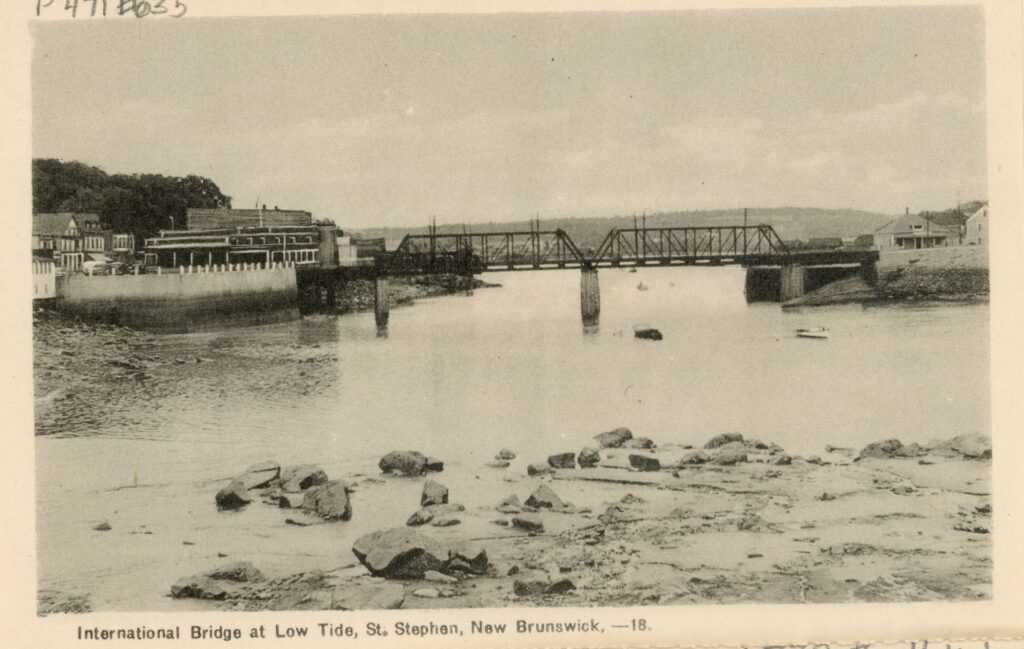
Three international crossings from Canada to the USA cross the St. Croix River including the downtown Ferry Point Bridge, further upstream the Milltown International Bridge, and the upriver International Border Third Bridge.
Activity: Make your own Passport
https://www.youtube.com/watch?v=LDXv1OkYFdU
The St. Croix River is one of Canada’s Heritage Rivers, along which the Peskotomuhkati and other First Nations lived for more than 4000 years. Look for evidence of the lumber industry in the many rips and rough water that cover sunken logs, making river canoeing trips exciting.
https://chrs.ca/en/rivers/st-croix-river
The natural habitat of the river is also known for snapping turtles, osprey, eagles, and moose as well as trout, salmon, and pickerel. Many young people in the area grew up learning to canoe the river. For canoe trips, visit
https://www.stcroix.org/
Near downtown St. Stephen alongside the St. Croix River, enjoy a hike near the Dennis Stream, the site of a former axe factory. Look for the Dennis Stream Trail https://www.alltrails.com/es/trail/canada/new-brunswick/dennis-stream-trail
Activity: Make a compass. Francis Ganong used a compass in his
mapmaking. Try your hand at making one.
https://www.bbc.co.uk/bitesize/topics/zrvbkqt/articles/zfb6pbk
McADAM
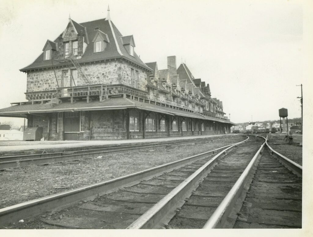
Architect Edward Maxwell designed this massive and fantastic railway station/hotel built in 1900 for the Canadian Pacific Railway (CPR). As head of the CPR Sir William Van Horne commissioned Maxwell to design the train station, two years after Maxwell designed Van Horne’s house and barn on Minister’s Island. While there is no longer passenger service on the railway here, part of the building is the McAdam Station Museum. https://www.mcadamstation.ca/
Behind the station a six acre pond was dug for water for steam engines. Visit the McAdam Nature Trail that loops around the pond.
https://www.alltrails.com/trail/canada/new-brunswick/mcadam-nature-trail
DIGDEGUASH RIVER
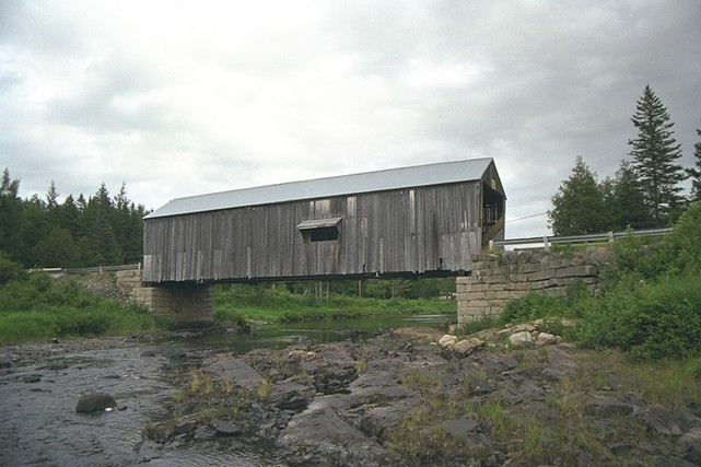
On your way along Route 127 East towards St. George, travel up the Digdeguash River to McGuire Covered Bridge at Elmsville. One of seven remaining in the county, covered bridges are constructed entirely of wood and were enclosed to protect the wood structure from rain and snow.
https://tourismnewbrunswick.ca/listing/digdeguash-river-no-3-covered-bridge-mcguire
Activity: Build a popsicle stick-covered bridge
https://www.garrettsbridges.com/design-it/
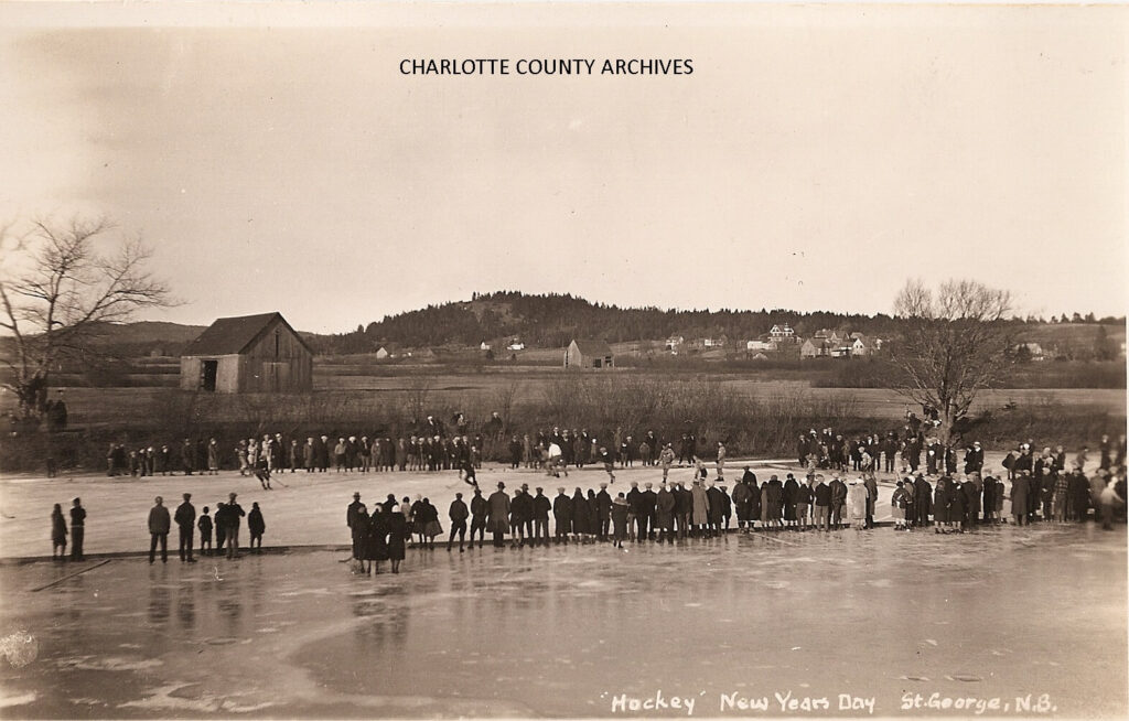
ST. GEORGE
At one time, the town was called Granite Town after the numerous red- granite quarries that made St. George the center of the granite industry in New Brunswick. The town’s Post Office on Portage Street, built of light gray and light red split granite is a physical reminder of the industry. In its heyday, there were about 50 quarries with 6 stone-cutting businesses in St. George.
One of the St. George granite companies, Henry McGrattan and Sons, is believed to have supplied granite for black granite headstones that mark the graves of 149 victims of the sinking of the Titanic in a Halifax cemetery.
http://quoddytides.com/quoddy-quarry-rock-cut-for-titanic-headstones%204-13-2018.html
The Magaguadavic River flows through the centre of town at First Falls, falling 21 metres into a gorge that empties into a tidal basin. Since 1784, hydropower from the falls has powered shipbuilding, lumbering and sawmills, granite works finishing sheds, and a pulp mill. The mill beside the falls is now an electrical power generating plant. https://stgeorgepower.ca/
The world’s first artificial fishway was built into the gorge at First Falls in 1928. The Salmon Fish Ladder is made of 43 concrete pools resembling a staircase of water cascading from pool to pool. Visit the fish ladder at Upper Gorge Picnic Area. https://www.historicplaces.ca/en/rep-reg/place-lieu.aspx?id=8973
While here, look for the famous Old Pine Tree, an eastern white pine overlooking the gorge. This tree is believed to be one of the oldest living trees in New Brunswick.
https://www.rhp-rlp.gnb.ca/Page1.aspx?blnLanguageEnglish=True&RID=1154&VER=2&dp=1
Other places where there is evidence of the granite industry are the remains of a wharf and a granite-works shed at Eagles Nest Picnic Area. Here, granite was loaded on ships that traveled along the Magaguadavic River into Passamaquoddy Bay, then the Bay of Fundy, and to international markets.
http://www.townofstgeorge.com/explore/places-to-see/eagles-nest/
Today, St. George is the hub of the salmon aquaculture industry in the Bay of Fundy with fishermen and workers from throughout the county. Look for salmon cages as you travel by boat or ferry to the Fundy Bay islands, or along the coast.
Many of the large homes in St. George are related to the past, including the Bridge Superintendent’s House, 21 South Street. In the early 1900s the superintendent was responsible for creating a shorter work week from six days a week to Saturday afternoons off for men working on the bridge. This gave the workers time off and helped the local economy.
https://www.rhp-rlp.gnb.ca/
Explore river life by hiking these trails: St. George Marsh Trail, St. George River Trail, Ducks Unlimited Walking Trail and Fundy High Red Trail.
https://www.alltrails.com/trail/canada/new-brunswick/st-george-marsh-trail
PENNFIELD
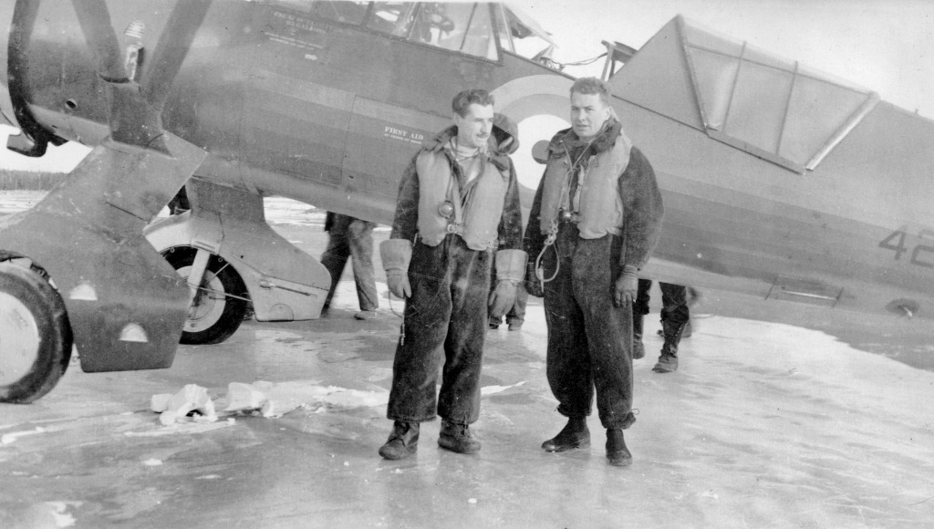
Pennfield got its name from American Quakers and Loyalists who settled the area in 1783 because of the American Revolution and remaining loyal to the British Crown. In 1940, Pennfield Air Ridge Station was built here to train pilots for WWII action in Europe and to fight against German submarines in the Atlantic Ocean. A few officers’ houses remain nearby but after the war, the airfield was used briefly for commercial flights. Today the former airfield is used to dry seaweed.
http://sites.rootsweb.com/~nbpennfi/penn8b1AirStationHistory.htm
Activity: build a paper airplane
https://www.hgtv.com/design/make-and-celebrate/handmade/how-to-make-a-paper-airplane
GREEN’S POINT LIGHTHOUSE AND MUSEUM
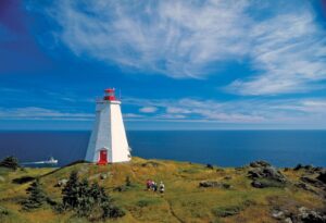
Visit the lighthouse that overlooks L’Etete Passage, an important marine navigation area between the mainland and Deer Island. The first lighthouse and fog alarm was erected here in 1897. While the light has been decommissioned since 1999, the fog horn is still in use. If you visit on a foggy day, you’ll hear it!
The Interpretive Centre in the lighthouse keeper’s cottage has displays on the lighthouse, coastal flora and fauna, and local marine industries. The area around the lighthouse is great for picnicking and exploring the coastline. https://www.lighthousefriends.com/light.asp?ID=1024
BLACK’S HARBOUR
This small village and harbour is where the largest sardine factory in the world was established in 1885 by Lewis and Patrick Connors. Connors Brothers’ factory first canned clams, scallops and later sardines, along with some locally grown fruit. Located near rich fishing grounds, Connors Brothers expanded rapidly, importing expertise and workers from around the globe. Over the years, the company began to build workers’ housing, schools and stores, while providing most of the employment. Learn more about life in a company town here:
https://archive.macleans.ca/article/1951/8/1/the-fish-that-paid-for-a-town
http://www.connors.ca/english/full_sardine_video.php
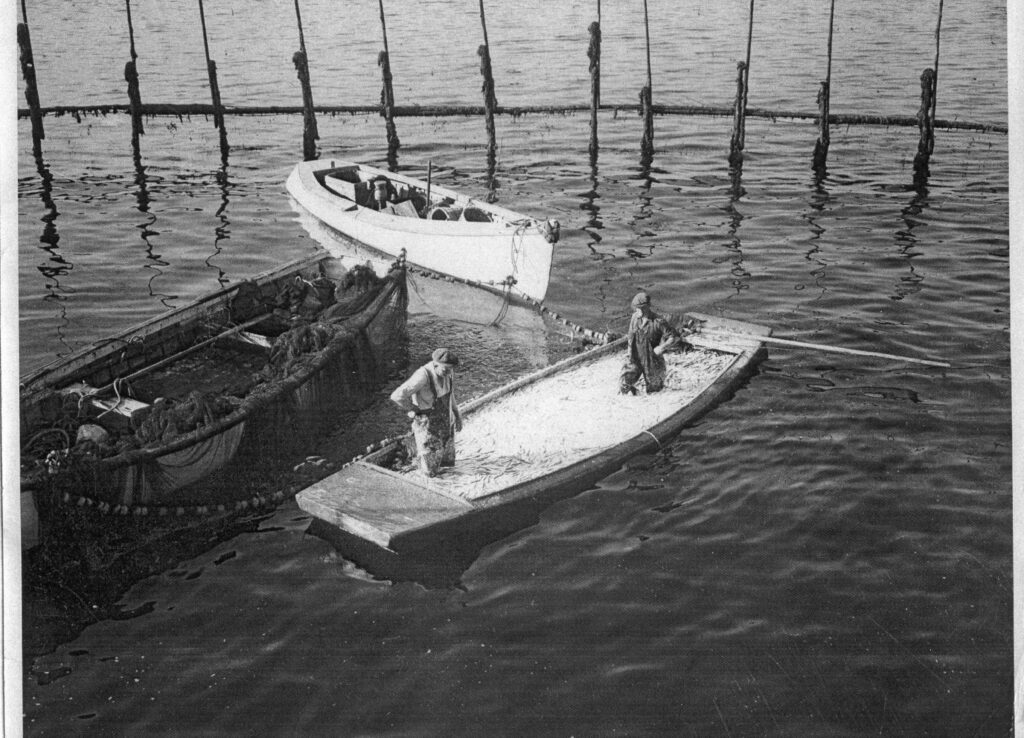
Herring is considered a key species in the Bay of Fundy. Look along the mainland coast and on all the islands in the bay, for stationary fish traps or weirs. Weirs are circles of tall wooden posts bounded by nets. Traditionally, the Peskotomuhkati built weirs to catch schools of young herring as they swim along ocean currents. Modern herring weirs are similar but fish are collected often in purse nets by boats called seiners.
Since the early 1980s there has been a huge decrease in the use of weirs due to economic factors and fewer herring. Many weir sites have changed to aquaculture sites and the farming of salmon, other fish, molluscs, and crustaceans. https://www.aquaculture.ca/
https://www.dfo-mpo.gc.ca/aquaculture/sector-secteur/commun/charlotte-eng.htm
http://gma.org/herring/harvest_and_processing/weirs/default.asp
https://www.thoughtco.com/fish-weir-ancient-fishing-tool-170925
As you tour around Black’s Harbour, check out Wallace Cove Trail for a fun walk or hike and visit nearby the Connors Bros Nature Preserve and Pea Point Lighthouse. https://www.naturetrust.nb.ca/en/connors-bros-at-pea-
point-nature-preserve
https://www.alltrails.com/explore/canada/new-brunswick/blacks-harbour
Black’s Harbour is the ferry landing for the Grand Manan Island ferry. While onboard the ferry, keep a lookout for whales, porpoises, sharks and seabirds. https://grandmanan.coastaltransport.ca/schedule.html
DEER ISLAND
First settled by Europeans in the 1700’s, this small island is reached by a short ferry ride from the mainland at L’Etete, a few miles from St. George. During the ferry crossing, you may see seals, porpoises, different kinds of whales and seabirds. Look for sea farming cages, close to land in deep water. On the island Eagle Shadow Hiking Trail begins and ends in Chocolate Cove. https://www.alltrails.com/explore/trail/canada/new-brunswick/chocolate-cove-on-deer-island
https://deerisland.coastaltransport.ca/schedule.html
Off the south end of the island, Old Sow Whirlpool is the largest tidal whirlpool in the western hemisphere. The whirlpool is the result of an underwater trench and an undersea mountain impacting on tides flooding into Passamaquoddy Bay from St Croix River countercurrents. There are reports of ships and sailors being swallowed up by Old Sow.
https://www.smithsonianmag.com/travel/close-encounters-with-the-old-sow-48091759/
Also at the southern tip of the island is Deer Island Point Park, a public camping and picnic site that overlooks Eastport, Maine. Ferries connect Deer Island to Campobello Island. www.eastcoastferriesltd.com
Activity: Create an origami jellyfish
https://www.youtube.com/watch?v=wfCnm5SgXY4
CAMPOBELLO ISLAND
Take the ferry from Deer Island or cross the international bridge from Lubec, Maine, to reach this magical island. It's a great place for whale and seal watching, hiking, biking, camping, kayaking, hunting for sea glass, and visiting lighthouses. The famous Head Harbour Lightstation can be visited at low tide. http://www.campobello.com/lighthouse/litehistory.html
Mulholland Lighthouse is part of the Roosevelt Campobello International Park, an international park jointly owned and managed by both Canada and the United States, and the summer home of American President Franklin Roosevelt (1882 -1945). In summer, there are fun and special events for all ages at the park and in the Roosevelt home and buildings.
https://www.rooseveltcampobello.org/what-to-see-and-do-index
Another great place to hike, camp and collect sea glass is at Herring Cove Provincial Park. Look for bald eagles, osprey, gulls, seals, dolphins and other sea mammals.
Activity: Keep a checklist of what you see and hear. See if you can identify
it on the Internet or by using an app (try PlantNet, iBird iNaturalist,
MyNature Animal Tracks, and Google Sky Map). Use a chart like this :
| My Sea Mammals Checklist | ||
|---|---|---|
| Sea Mammals (ie whales, seals ) | Birds (ie great black- backed gulls) | Crustaceans (ie scallops) |
GRAND MANAN
The largest island in Passamaquoddy Bay and the farthest from the mainland, was named Mun-an-ook or Man-an-ook by the Peskotomuhkati people and believed to be a sheltered winter habitation for their elders. Like other islands in the bay, it was settled by Loyalists fleeing the American Revolution as well as settlers from other places.
The island is a treasure trove of lighthouses, with Swallowtail LightHouse and Light keeper’s House at Grand Harbour. Check out the views of salmon cages, whales and other sea life from the top of the lighthouse reached by ladder. The Lighthouse Museum, Grand Manan Museum, and Grand Manan Whale and Seabird Research Station, all in Grand Harbour have interesting collections of artifacts and lots to learn about sealife, fishing and the history of the island.
http://www.grandmanannb.com/pdf/Sealife-herring_and-weirs.pdf
http://www.grandmanannb.com/pdf/Sealife-fishing.pdf
Grand Manan and nearby White Head Island are centres of the Fundy Bay area seaweed and dulse industries. A short ferry ride in summer takes you to WhiteHead Island. Enjoy a salty dulse snack during your visit to the islands.http://www.grandmanannb.ca/ATTRACTIONS_Whitehead.html
http://www.grandmanannb.com/pdf/Sealife-seaweeds.pdf
Check out the many stories about shipwrecks off Grand Manan:
https://www2.gnb.ca/content/gnb/en/gateways/about_nb/grand_manan/shipwrecks.html
Like all lighthouses, Gannet Rock Lighthouse, several kilometers off the coast of Grand Manan was built to warn ships about marine hazards. Long Eddy Point Lighthouse, on Whistle Road called “The Whistle” because of its foghorn is a great whale watching and birdwatching site.
https://www.pc.gc.ca/apps/dfhd/page_hl_eng.aspx?id=15292
Visit Seal Cove Smoked Herring Stands at Seal Cove, where 54 wooden buildings, wharves, weirs and stands are reminders of the island’s past as an important smoked herring centre; many fishermen worked the boats while women and children processed the catch. The sandy beaches and sand dunes nearby are good for beach walks and sun bathing.
https://www.pc.gc.ca/apps/dfhd/page_nhs_eng.aspx?id=863
Visit Eel Brook Falls as part of a hike along Lighthouse Trail that travels around the coastline of Grand Manan Island. The Trail gives hikers a view of high cliffs and outlooks over the ocean.
http://www.hikingnb.ca/Trails/FundyWest/GrandManan/LighthouseTrail.html
https://tourismnewbrunswick.ca/story/15-best-waterfalls-nature-lovers
The Migratory Bird Sanctuary is a great site for birdwatching and is near Anchorage Provincial Park in Grand Harbour. Visit here for a list of the birds that stop over on the island during their migration.
https://www.canada.ca/en/environment-climate-change/services/migratory-
bird-sanctuaries/locations/grand-manan-island.html#toc3
Learn more here about birds and their migration on Grand Manan:
https://www.ibacanada.com/site.jsp?siteID=NB011&lang=EN&siteID=NB011&lang=EN
If you love to eat lobster, try some while on the island, one of the main centres of the industry. Visit Woodward’s Cove to see holding tanks and lobster pounds used to hold the crustaceans until they go to market.
http://www.grandmanannb.com/fishing.html
Activity: Build your own Lighthouse
https://www.youtube.com/watch?v=yvClQo2G4XI
Credits: All photographs are the collection of Charlotte County Archives, except
for no. 3 – NOAA Fisheries; no. 5 – en.wikipedia.org; and no. 11 – Pennfield
Parish Military Historical Society. The Road Trip was inspired by a similar project
of the Smithsonian Institute https://www.si.edu/
Charlotte County Road Trip Activity Guide
is a publication of the Charlotte County Archives.
Donations to help with projects like this can be made at https://ccarchives.ca/donations/
Become a member at https://ccarchives.ca/membership/